


This article was written regarding work conducted under legacy company names: Continental Mapping, GISinc, or TSG Solutions. These three companies merged in January 2021 to form a new geospatial leader Axim Geospatial.
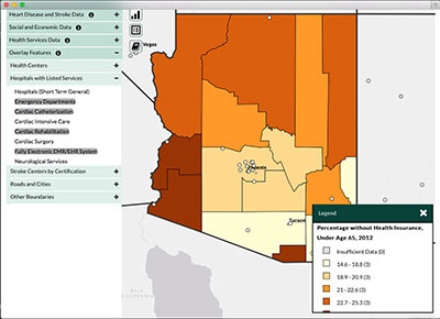
The Centers for Disease Control and Prevention (CDC) is a major operating arm of the US Department of Health and Human Services. This application was developed for the Division for Heart Disease and Stroke Prevention (DHDSP) of the CDC. The main goal of the DHDSP is to improve cardiovascular health through programs that promote healthy communities as well as access to detection and treatment. The Interactive Atlas of Heart Disease and Stroke application gives health stakeholders and the general public the ability to explore heart disease and stroke statistics for the United States. One of the goals of the DHDSP is to provide health stakeholders and the public with yearly data that can be shown at the state or county level. The DHDSP compiled a set of heart disease and stroke data but needed a way to allow users to explore the data through characteristics, spatial, and temporal methodologies. The application also needed to be flexible enough to allow users to simultaneously compare different themes and time periods.
The goal of version 2.0 of the Interactive Atlas provided users with requested enhancements and the ability to view the application on mobile devices. The main focus of version 2.0 included migrating the web application from Adobe Flex to an HTML/JavaScript viewer, which allows the application to be accessible on more platforms and devices. The application uses the ArcGIS API for JavaScript to display maps through a web browser. ArcGIS Server is used to serve map and geoprocessing services which provide the spatial data and print capabilities for the web application. The application also uses custom .NET web services to dynamically query and combine a large collection of theme tables with spatial locations. The web services also anonymously track how users interact with the web application and provide metrics to allow DHDSP to tailor the datasets that users are interested in exploring.
Their new application is significantly improved from user experience to functionality over its previous incarnation. This application aids in the process of researching correlations between various environmental factors and health outcomes.

