


This article was written regarding work conducted under legacy company names: Continental Mapping, GISinc, or TSG Solutions. These three companies merged in January 2021 to form a new geospatial leader Axim Geospatial.
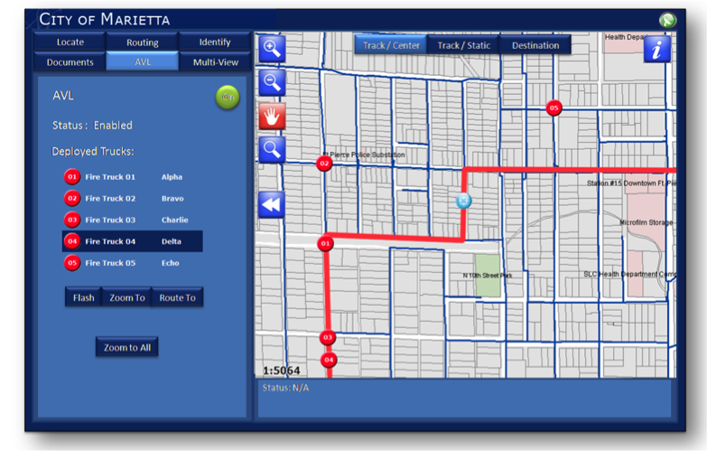
We developed the GIS Fire Mobile Solution (GFMS) for the City of Marietta, which leverages the existing ROCKET system (laptops connected to a wireless network with GPS). Powered by Esri's ArcGIS Server Mobile technology, the GFMS accomplished the primary objective of providing the Fire Department with immediate access to up-to-date information, regardless of their location, and offers a range of mobile GIS field mapping solutions that apply these current technologies to help users make sound decisions in the field. Additionally, the GFMS provides routing, preplan tools, and builds the foundation for future field edits that can be synchronized to a command center and real-time edits from the field providing command and control with information to make effective decisions.
Some of the key features of GFMS include:
- Users can search by address, intersection or any feature in the mobile map cache
- Users can get information from features on the map and it supports hyperlinks
- Standard map navigation and routing tools
- Sync mobile devices with ArcGIS Server mobile services and preplan documents Global Positioning System (GPS) Enabled real-time tracking
- Routing will support two forms of routing: Origin to destination and Multiple Destinations
- AVL real-time location display of all fire rescue vehicles running the GFMS
- Preplan Tool - access documents linked to features on a map (building plans, HAZMAT, etc.)
- Multi-View Service Tool - provides access to Google Street View and Microsoft Virtual Earth Birdseye

